Automatic Identification System (AIS) overview
AISAIS uses digital radio signals to broadcast ‘real-time’ information between vessels and shore-based stations via dedicated VHF radio frequencies. This information is used to identify and track vessels in the surrounding area and to provide fast, automatic and accurate collision avoidance data.
It is not mandatory for vessels to be fitted with operational AIS equipment. Therefore, you should not assume that ALL vessels in your area are displayed.
With AIS data available on your system, the AIS Favorite page can:
Display targets for any other local vessels that are equipped with an AIS-transceiver.
Display voyage information being broadcast by these targets, such as their position, course, speed and rate-of-turn.
Display basic or detailed information for each target vessel, including safety-critical target data.
Set up a safe zone around your vessel.
View AIS alarms and safety-related messages.
AIS information is displayed on the screen as shown below:
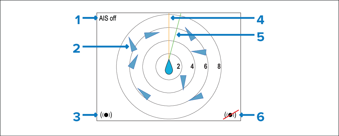
AIS messages (See AIS messages list below).
AIS targets.
Dangerous targets alarm on.
Heading line.
COG line.
Dangerous targets alarm off.
If no AIS message is displayed then AIS is enabled and transmitting.
A maximum of 25 targets can be displayed. Where more than 25 targets are in range, a ‘Max targets’ message is displayed onscreen.
Where unstable or no Heading or COG data is available, AIS targets and your vessel icon will not be displayed.
AIS MessagesAIS messages
AIS off — AIS switched off
Alarm on icon — Transmitting, alarm is active.
Silent — Silent mode is enabled; AIS not transmitting.
Alarm on — Silent mode is enabled and alarm is active.
Alarm off icon — Transmitting AIS. Alarms are switched off.
Data lost — Transmitting AIS. AIS target lost.
No fix — No GNSS (GPS) fix.
Insufficient COG / Hdg data — Unstable COG or heading data.