Find nearest
The Find nearest feature allows you to select a location and search for nearby objects or points of interest.
The level of detail available on charts is dependent on vendor, chart type, subscription level and geographic region. Prior to purchasing charts check the vendor’s website to establish what level of detail is available on the charts you want to purchase.
The information relating to available chart detail and settings in this manual should be treated as guidance only as it is subject to change that is not under Raymarine’s control.
ChartFind nearestChartSearch for objects
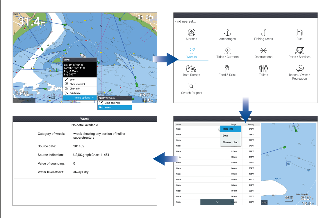
Selecting a location and pressing the OK button will open the Chart context menu, selecting more options and then Find nearest will display the Find nearest options page where you can select the type of place or object you want to search for.
Selecting an option will display a list of all nearby objects for that type. The list is sorted by an object’s proximity to the selected location. However, the Range and Bearing displayed is relative to your vessel’s position.
Find nearest options
Legacy LightHouse Charts refers to retired LightHouse vector, raster and NC2 Charts.
The options available on the find nearest page depend on the cartography type you are using:
Marinas (LightHouse Charts, Navionics and C-Map)
Anchorages (LightHouse Charts)
Fishing Areas ( LightHouse Charts)
Fuel (LightHouse Charts)
Wrecks (LightHouse Charts, Legacy LightHouse Charts, Navionics and C-Map)
Tides (LightHouse Charts, Legacy LightHouse Charts, Navionics and C-Map)
Currents (LightHouse Charts, Legacy LightHouse Charts, Navionics and C-Map)
Lakes (Navionics and C-Map)
Obstructions (LightHouse Charts, Legacy LightHouse Charts, Navionics and C-Map)
Ports/Services (LightHouse Charts, Navionics and C-Map)
Boat Ramps (LightHouse Charts)
Food & Drink (LightHouse Charts)
Toilets (LightHouse Charts)
Beach/Swim/Recreation (LightHouse Charts)
Search for port (LightHouse Charts, Legacy LightHouse Charts, Navionics, C-Map)
Small Craft Facility (Legacy LightHouse Charts)
Harbor Facility (Legacy LightHouse Charts)
Businesses (Navionics)
Point of interest (C-Map)
Outdoor Recreational Areas (ORA) (C-Map)
ORA Services (C-Map)
List options
From the list of found objects or places the following pop-over options are available for each item in the list:
View more information about the object by selecting More info.
Navigate to the selected object by selecting Goto.
Display the selected object in the Chart app by selecting Show on chart.
When an item from the list is selected the LiveView on the right of the screen will highlight and zoom to the selected object.